In Newmarket, the difference between a straightforward permit and a costly redesign often comes down to one thing: the seismic site class. We see it all the time—contractors assume the glacial till under Holland Landing is just 'stiff soil' until an MASW survey proves otherwise. The Ontario Building Code references NBCC 2020, and municipalities across York Region now routinely request VS30 data for mid-rise structures. Rather than relying on proxy tables that can overestimate capacity, our crew deploys a 24-channel geophone spread to measure shear wave velocity directly. For deeper bedrock profiling where the till transitions into the Georgian Bay shale, pairing this survey with seismic refraction often clarifies the contact depth. And if you are already planning borings, integrating an SPT drilling program with the velocity profile gives you a defensible ground model that satisfies both the geotechnical engineer and the plan reviewer at the town office on Mulock Drive.
VS30 is not just a number for the building permit—it is the parameter that determines whether your seismic design category jumps from SC3 to SC2, with real implications for structural costs.
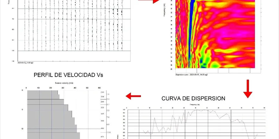
Methodology and scope
Local considerations
The glacial stratigraphy under Newmarket is not as uniform as the topography suggests. The Newmarket Till—a dense, silty-clay diamict deposited by the Ontario lobe of the Laurentide Ice Sheet—sits above interstadial sands and gravels of the Thorncliffe Formation in many parts of town. That layering creates a velocity profile where a stiff upper unit overlies softer material, and a VS30 value that averages the two can mask a real impedance contrast at 12 to 18 metres depth. If the site is near the Holland River floodplain, the water table sits high, sometimes within 2 metres of grade, and saturated fine sands introduce a liquefaction susceptibility that VS30 alone does not capture. For projects on the east side near the Oak Ridges Moraine, the sediment package can exceed 100 metres before bedrock, meaning the 30-metre average genuinely represents the dynamic response. When the borehole logs suggest loose granular layers within the upper 15 metres, we recommend a complementary liquefaction assessment based on SPT blow counts to cross-check the velocity-based screening.
Applicable standards
ASTM D4428/D4428M-14 Standard Test Method for Crosshole Seismic Testing (surface wave adaptation), NBCC 2020 Division B, Article 4.1.8.4 – Site Classification for Seismic Site Response, CSA A23.3-14 Annex N – Seismic Design of Concrete Structures (site class input), Ontario Regulation 332/12 – Building Code (reference to NBCC seismic provisions), Canadian Foundation Engineering Manual (CFEM) 4th Edition – Section 3.4 on dynamic soil properties
Associated technical services
VS30 Site Classification Survey
Full 24-channel MASW acquisition at one or more array locations, processed to NBCC 2020 site class with signed and sealed report. This is the core service for building permit submissions in Newmarket and covers the shear wave velocity averaging required by the code.
Combined MASW and Refraction Package
When bedrock depth is uncertain, we run a seismic refraction line alongside the MASW spread. The refraction picks the P-wave velocity of the till-shale interface, while MASW gives the shear wave profile—two independent constraints that tighten the ground model significantly.
Downhole Vs Calibration
For projects where a borehole is already planned, we lower a triaxial geophone into the casing and measure Vs directly at 1-metre intervals. This data calibrates the surface MASW dispersion curve and eliminates any doubt about velocity inversions in the upper 10 metres.
Typical parameters
Frequently asked questions
What does a MASW / VS30 survey cost in Newmarket for a typical residential lot?
For a standard single-family lot or small commercial parcel in Newmarket, MASW surveys generally range from CA$2,470 to CA$3,820 depending on the number of array positions, access conditions, and whether the report requires a P.Eng. stamp for the building department submission. A single-array survey with one VS30 profile falls at the lower end; adding a second orthogonal array or combining it with a refraction line moves toward the upper range. We provide a firm quote after reviewing the site address, as factors like slope, buried utilities, and proximity to Highway 404 influence the field time.
How long does the field work take, and will it disrupt the job site?
The field crew usually completes a single MASW array in 45 to 90 minutes on site, including layout, testing, and demobilization. The geophones and cables sit on the ground surface—no drilling, no excavation, no heavy equipment. We need a relatively clear strip of ground about 50 metres long, but we can work around stockpiles, parked vehicles, and existing structures as long as we have a straight line of sight. The only noise is the hammer strike, which is about as loud as a fence post being driven, repeated 5 to 10 times per shot point.
Can MASW replace boreholes for seismic site classification in Ontario?
MASW is accepted by the Ontario Building Code as a direct method for determining the average shear wave velocity in the upper 30 metres, which is the basis for NBCC site classification. However, it does not provide soil samples for laboratory testing, so most projects in Newmarket combine MASW with at least one borehole or test pit to confirm stratigraphy. The velocity profile from MASW is actually more representative of the bulk in-situ conditions than borehole-based methods because it samples a larger volume of soil and avoids disturbance effects from drilling. The two techniques are complementary, not interchangeable.